Command and Control
Tiltan's Command and Control solution is a complete C4I suite that enables military units and public safety forces to conduct realistic 3D mission planning, battle field visualization, command and control and post mission analysis. Proven in multiple installations, Tiltan Command and Control excels in providing a unified, contextual, and multi-dimensional visual view of the battle field that facilitates situational awareness and enables effective decision making.
Using this comprehensive solution, forces can rehearse missions in advance, achieve visibility and command and control over field forces in real time, maximize operational effectiveness and make better critical decisions under stress.
Tiltan's Command and Control visualization solution delivers value in multiple ways:
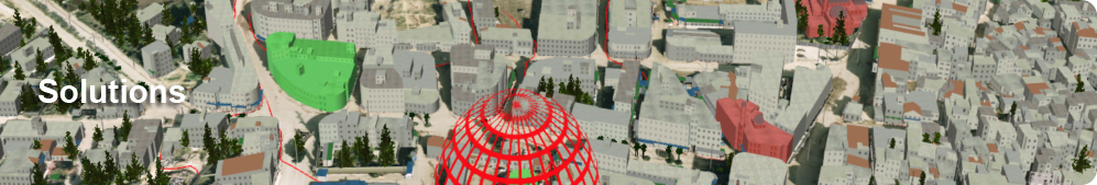
Realistic 3D Mission Planning and Rehearsal. Tiltan offers the most realistic and detailed 3D modeling, for all terrains and for any level of details. This enables interdisciplinary mission units to realistically view and rehearse the operational field from their unique point of view (ground, vehicle mounted, airborne) with an unmatched level of detail. Forces can rehearse and train for any imaginable scenario, learn the exact routes and obstacles of the terrain and practice the interaction between units. Tiltan Command and Control accurately simulates hundreds of moving objects, including aircraft, missiles, ground vehicles, humans and animals.
Any Geographical Environment. Tiltan's comprehensive visual modeling capabilities can model any environment based on your specific needs. The solution delivers rapid generation of photorealistic visual and sensor scenes of real-world locations in virtually unlimited size.
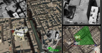
Enhanced Situational Awareness for Effective Response. Tiltan unifies multiple data feeds and geospatial information into one cohesive picture that enables optimal situational awareness and rapid decision making. For instance, real-time video feeds are imposed over the 3D visual presentation or 2D map location so that decision makers can immediately be made aware of events in the vicinity of field forces and accurately assess the situation with full understanding of geospatial relationships.
Real-Time Sensor Control. Sensors can be fully controlled to receive the desired view of the territory.
After-Action Review (AAR). Tiltan sessions may be recorded and replayed at a later time, facilitating effective after-action review.