United Views SDK

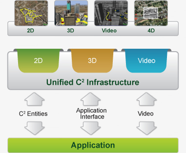
Tiltan's United Views software development kit (SDK) allows developers to design, implement and test a comprehensive visual presentation layer for advanced C4ISR systems. Developers can efficiently combine multiple visual data sources such as 3D geo-spatial data, 2D maps, video feeds and vector symbols and present them in a unified, coherent view to end users.

United Views consists of a comprehensive development environment that includes a core 3D rendering engine a 2D presentation viewing engine and a set of C++ modules, which together provide developers with all necessary building blocks for rapid implementation.

diagram

United Views Key Features

General

3D Visualization

  • In-window viewports
  • 2D and 3D view synchronization
  • Sensor mockup support
  • Entity management
  • Image generator for viewing terrain databases and models
  • Support for model animation
  • 3D query server analysis capabilities, displayed as 2D or 3D color-coded overlays and icons

2D Capabilities

  • Present multiple types of graphical layers - orthophoto, digital maps, aerial and space photography
  • On-the-fly transformation of coordinate systems
  • Presentation and manipulation of any layer in any reference system
  • Layer overlays during presentation
  • Aerial photo mosaics
  • NATO symbols
  • Support for GDI+, DirectX and OpenGL

Video

Vectors, Text and Overlay

  • Support for MPEG-2, MPEG-4 and H.264 decoding
  • C4I annotations over live registered video to display exact location of video feed
  • Vectors drawn and edited directly on the terrain
  • Configurable visual properties (color, width, intersection markers)
  • Text labels at geo locations and billboard text at specific x,y coordinates
  • 3D terrain overlays (rectangles, polygons, circles etc.)
  • Shape-file (.shp) vector file support
  • User-defined 3D amorphic shapes